A map Exhibiting all the New Discoveries in the Interior...


 Mapas, planos y cartas náuticas
A map Exhibiting all the New Discoveries in the Interior Parts of North America : Insoribed by Permission to the... (1796)
Mapas, planos y cartas náuticas
A map Exhibiting all the New Discoveries in the Interior Parts of North America : Insoribed by Permission to the... (1796)
 Disponible Ejemplares
 Sección: Mapas, planos y cartas náuticas
Título uniforme: CANADA. Mapas generales (1796). 1:4400000
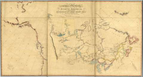
Título: A map Exhibiting all the New Discoveries in the Interior Parts of North America : Insoribed by Permission to the honorable Governor and Company of Adventures of England Trading into Hudson Bay In testimony of their liberal Conmunications / To Their most Obedient and very Humble servant A. Arrowsmith
Área de datos: Escala[ca. 1: 4400000], 240 millas geomÚtricas ^= 10 cm ! ; proyección cónica simple] (O 175° 00' 00'' -- O 30° 00' 00'' / N 70° 00' 00'' -- N 35° 00' 00'')
Publicación: [London : A. Arrowsmith], Charles Street, Soho, 1796
Descripción física: 1 map. : col., montado sobre tela ; 92 x 168 cm
Notas: Comprende Canadá, Alaska y N. de Estados Unidos, destacandose la red hidrográfica
Fecha de publicación de la edición original 1 de enero de 1795
Escala gráfica ademßs de 300 millas britßnicas de 69 1/4 al grado ^ = 10,8 cm !
Orografía representada por normales. Sondas batimétricas
En la costa O. aparecen señaladas derrotas en sus fechas. Se señalan las corrientes marinas en la Bahía de Hudson
El título aparece encuadrado entre cintas
En el margen inferior izquierdo figura una relación con los nombres de losdescubridores y color empleado para diferenciar las zonas exploradas por cada una de ellas
Materia / lugar / evento: Mapas generales
Descubrimientos geográficos
Hidrografía
Derroteros
1796
Alaska
Estados Unidos
Otros autores: Arrowsmith, Aaron, 1750-1823
CDU: 912:551.48:910.4(71)"1796"
-(71)
798
Tipo de publicación:
Mapas
Derechos:
Préstamo:
Disponible
