Chart of the Caribbee islands : from the spanish survey,...


 Mapas, planos y cartas náuticas
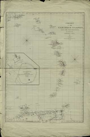
Chart of the Caribbee islands : from the spanish survey, with a sketch of the Anchorage at Nevis (1808)
Mapas, planos y cartas náuticas
Chart of the Caribbee islands : from the spanish survey, with a sketch of the Anchorage at Nevis (1808)
 Disponible Ejemplares
 Sección: Mapas, planos y cartas náuticas
Título uniforme: Caribe (Mar). Cartas náuticas (1808). 1:1221001
Título: Chart of the Caribbee islands : from the spanish survey, with a sketch of the Anchorage at Nevis / E. Janés sculpt
Área de datos: Escala [ca. 1:1.221.001]. Escala hallada a partir de un grado de latitud [= 9,1 cm] (O 65°35'--O 59°20'/N 18°40'--N 10°00')
Publicación: London : Arrowsmith, A, 1808
Descripción física: 1 mapa ; 80 x 58 cm
Tipo de contenido: Imagen cartográfica
Tipo de medio: computadora
Tipo de soporte: recurso en línea
Notas: Indice número de sonda y veriles
Inserta "Sketech of Nevis and part of St. Christophers with Bearings to shew the marks for anchoring at Nevis & the Baukof Nags head two nautic miles [= 5 cm]"
Inserta "Sketech of Nevis and part of St Christophers with Bearings to shew the marks for anchoring at Nevis & the Baukof Nags Head two nautic miles [= 5 cm]
Materia / lugar / evento: Cartas náuticas
Caribe (Mar)
Otros autores: Arrowsmith, Aaron, 1750-1823
Jones, Edward
CDU: 912:551.46(729)"1808"
729
Tipo de publicación:
Mapas
Derechos:
Préstamo:
Disponible
