A Map of a part of Yucatan or of that Part of the Eastern...


 Mapas, planos y cartas náuticas
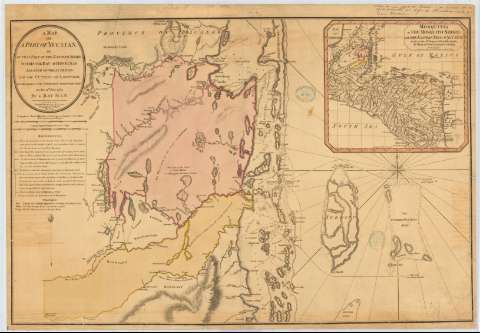
A Map of a part of Yucatan or of that Part of the Eastern Shore within the Bay of Honduras alloted to Great Britain... (Febr. 1st. 1787)
Mapas, planos y cartas náuticas
A Map of a part of Yucatan or of that Part of the Eastern Shore within the Bay of Honduras alloted to Great Britain... (Febr. 1st. 1787)
 Disponible Ejemplares
 Sección: Mapas, planos y cartas náuticas
Título uniforme: BELICE. Cartas náuticas. 1787 (1786). 1:440916
Título: A Map of a part of Yucatan or of that Part of the Eastern Shore within the Bay of Honduras alloted to Great Britain for the Cutting of Logwood, in consequence of the convention signed with Spain on the 14th, July 1786 / by a bay-man
Área de datos: Escala [ca. 1:440916], 30 nautic miles [= 12'6 cm]
Publicación: London : Printed for Willian Faden, Geographer to the king, Febr. 1st. 1787
Descripción física: 1 carta náutica : col., papel agarbanzado con marca de aguas:"John Bates", montado sobre tela ; 57 x 82 cm
Tipo de contenido: Imagen cartográfica
Tipo de medio: computadora
Tipo de soporte: recurso en línea
Notas: Escala gráfica también expresada en 10 leguas comunes españolas [= 12'9 cm]. Orientado con lis en rosa de ocho vientos
Relieve por sombreado y de perfil
Indica sondas batimétricas, veriles y fondeaderos
Relación de los distintos puntos del plano y de los ejercicios bélicos que se desarrollaron contra los españoles en esta zona, indicados mediante clave
Clave cromática para señalar los límites del territorio perteneciente a Gran Brataña según los tratados de 1785 y los 186 asentamientos ingleses anteriores
Inserta: "Mosquitia on the mosquito shore with the Eastern Part of Yucatan". Escala [ca. 1:5291000], hallada por comparación con otros documentos de características similares. 23 x 24 cm.
Sello del depósito general topográfico de ingenieros; sello de la Biblioteca Central Militar. Mapas y planos (al verso)
Materia / lugar / evento: Cartas náuticas
Mapas generales
Estrategia militar
Fronteras
1786
1787
Yucatán
Honduras
Otros autores: Faden, William, 1749-1836
CDU: 728.2
728.3-11
728.3-17
Tipo de publicación:
Mapas
Derechos:
Préstamo:
Disponible
