Parts of Eastern and Southern Nevada, and Southern Utha...


 Mapas, planos y cartas náuticas
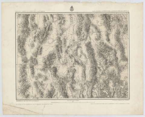
Parts of Eastern and Southern Nevada, and Southern Utha : expeditions of 1869-1872 & 1873 (187-?)
Mapas, planos y cartas náuticas
Parts of Eastern and Southern Nevada, and Southern Utha : expeditions of 1869-1872 & 1873 (187-?)
 Disponible Ejemplares
 Sección: Mapas, planos y cartas náuticas
Título uniforme: NEVADA (Estados Unidos) (Estado). SE. Mapas generales. 1872-1880? (1869-1872). 1:514992
Título: Parts of Eastern and Southern Nevada, and Southern Utha : expeditions of 1869-1872 & 1873 / Under the Command of 1st. lieut. Geo. M. Wheeler, Corps of Engineers by order of the Honorable W.M W. Belknap, Secretary of war, under the direction of Brig. Gen. A.A Humphreys, chief of engineers, U.S Army ; Weyss Herman & Aguirre Del.
Área de datos: Escala 1:514.992. 1 inch by 8 miles
Publicación: New York : The Graphic Co. Photo lith, [187-?]
Descripción física: 1 mapa ; 38 x 49 cm
Tipo de contenido: Imagen cartográfica
Tipo de medio: computadora
Tipo de soporte: recurso en línea
Serie: (Geographical explorations & surveys west of the 1oo th. meridian)
Notas: Comprende la parte este de California, el suroeste de Nevada, el noroeste de arizona y el suroeste de Utha
Escala también dada en forma gráfica de 50 millas
Relieve por normales
Materia / lugar / evento: Mapas generales
Accidentes geográficos
Ríos
Montañas
Utah
Nevada
Estados Unidos
Otros autores: Wheeler, George Montague
Aguirre
Humphreys, A. A (Andrew Atkinson), 1810-1883
Weyss
Herman
Graphic Company Photo (Nueva York)
CDU: 79
Tipo de publicación:
Mapas
Derechos:
Préstamo:
Disponible
