Fortsetzung oder Andere Ausgabe des Ing. Maj. Petri von...


 Maps, plans and nautical charts
Fortsetzung oder Andere Ausgabe des Ing. Maj. Petri von anderweitigen 12 Blatt sub. Litt. B der accuraten Situations... (1762?)
Maps, plans and nautical charts
Fortsetzung oder Andere Ausgabe des Ing. Maj. Petri von anderweitigen 12 Blatt sub. Litt. B der accuraten Situations... (1762?)
 Disponible Holdings
 Section: Maps, plans and nautical charts
Uniform title: ALEMANIA. SE. Mapas generales (1762). 1:25000
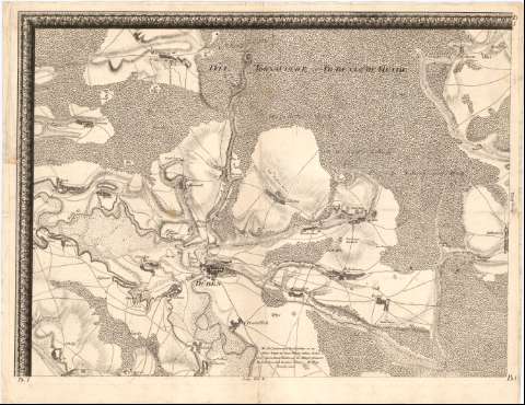
Title: Fortsetzung oder Andere Ausgabe des Ing. Maj. Petri von anderweitigen 12 Blatt sub. Litt. B der accuraten Situations und Cabinets carte von einem anderen Theile des Churfurstenthums Sachsen und hauptsachlich vondenen Gegenden auf beiden Seiten des Elbe und Muldau Stroms, und zwar am erstern von Meissen bis Prettin und der Gegend Pretzsch, und am letzteren von Doblen bis unterhalb Duben bei Rosa..
Material or type of resouce Area: [Ca. 1:25000], 2000 Rhein Ruth [= 10,7 cm]
Publication: [Dresden? : [Editor no identificado], 1762?]
Physical description: 1 mapa en 12 h. ; 194 x 208,5 cm en h. de 55 x 69,5 cm
Content type: Imagen cartográfica
Media type: computadora
Carrier type: recurso en línea
Notes: Comprende la zona del antiguo Estado de Sajonia entre el río Elba y el Moldan (Mulde)
Relieve representado por normales y sombreado
Nota relativa a la escala
Indica núcleos de población, cultivos, masas forestales, caminos, fortificaciones y el curso de los ríos con flechas
Título, nota y escala enmarcados en cartela barroca con una representación humana
Sello en seco del Depósito de la Guerra
Materia / lugar / evento: Mapas generales
Fortificaciones
Siglo XVIII
Leipzig
Sajonia
Alemania
Other authors: Petri, Isaak Jakob von, 1701-1777
UDC: 912:623.2](430-12)'1762'
(430-328 Leipzig)
(430-328 Sajonia)
Type of publication:
Maps
Rights:
Préstamo:
Disponible
