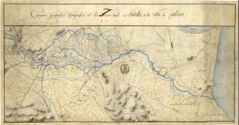
Croquis geográfico - topográfico del Rio Xucar désde...


 Maps, plans and nautical charts
Croquis geográfico - topográfico del Rio Xucar désde Antella a la Villa de Cullera (1811 ?)
Maps, plans and nautical charts
Croquis geográfico - topográfico del Rio Xucar désde Antella a la Villa de Cullera (1811 ?)
 Disponible Holdings
 Section: Maps, plans and nautical charts
Uniform title: JÚCAR (Río). Cuencas hidrográficas (1811). 1:44.600
Title: Croquis geográfico - topográfico del Rio Xucar désde Antella a la Villa de Cullera
Material or type of resouce Area: Escala [ca. 1:44600], 4000 varas [= 7,5 cm]
Publication: [1811 ?]
Physical description: 1 mapa : ms., col., montado sobre tela ; 34,3x82,5 cm, en h. de 48x85,8 cm
Content type: Imagen cartográfica
Media type: computadora
Carrier type: recurso en línea
Notes: Manuscrito a la acuarela
Orientado con flecha
Relieve representado por sombreado
Se dispone además del documento con sig. SG+Ar.G-T.2-C.3-126 bis, de igual contenido
Materia / lugar / evento: Cuencas hidrográficas
Carreteras
Caminos
Acequias
Ríos
1811
Antella
Cullera
UDC: 912:556.51]:[625.7:556.53:626.82](467.31 Antella+467.31 Cullera)'1811' %(467.31 Antella)
(467.31 Cullera)
(282.246 Jucar)
Type of publication:
Maps
Rights:
Préstamo:
Disponible
