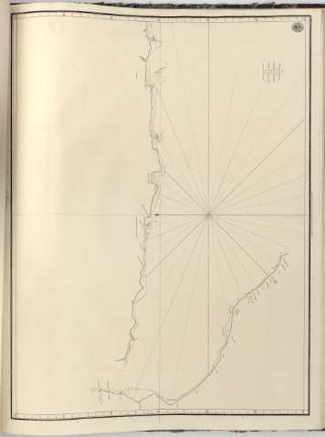
Chart of The Coast from Cape Arubah to The Entrance of...


 Maps, plans and nautical charts
Chart of The Coast from Cape Arubah to The Entrance of The Gulph of Persia (1781)
Maps, plans and nautical charts
Chart of The Coast from Cape Arubah to The Entrance of The Gulph of Persia (1781)
 Disponible Holdings
 Section: Maps, plans and nautical charts
Uniform title: Arabia (Península). Cartas náuticas. 1781 (1774). 1:1400000
Title: Chart of The Coast from Cape Arubah to The Entrance of The Gulph of Persia / Surveyed by Lient. William Robinfon
Material or type of resouce Area: [Ca. 1:1400000] (1774)
Publication: [London?] : Published according to Act of Parliament by A. Dalrymple, 1781
Physical description: 1 carta náutica ; 46 x 61 cm en h. de 50 x 64 cm
Content type: Imagen cartográfica
Media type: computadora
Carrier type: recurso en línea
Notes: Escala gráfica hallada a partir de un grado de latitud [= 7,5 cm]. Coordenadas referidas a un meridiano sin especificar (N 28°0'-N 22°0'). Orientado con lis en nudo de rumbos
Indica sondas batimétricas, veriles, bajos y fondeaderos
Sello del "Hydrographical Office"
En: Chart Red Sea
Materia / lugar / evento: Cartas náuticas
Costas
Golfos
Cabos
Penínsulas
1774
Golfo Pérsico
Arabia
Asia
Other authors: Robinson, William
Dalrymple, Alexander
UDC: 912:[551.46:551.468](567 Arab, calo)'1774/1781'
(26.04 Golfo Persico)
Type of publication:
Maps
Rights:
Préstamo:
Disponible
