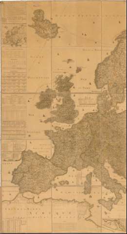
Carte de L'Europe


Section: Maps, plans and nautical charts
Uniform title: Europa. Mapas generales. 1798 (1797-1798). 1:3500000
Title: Carte de L'Europe / Par Jon tres humble et trés respectueux serviteur I.B. De Bourge Ingenieur Geographe Pensionne de Sa M. et ; Joannes Berken Scripsit
Material or type of resouce Area: Escala [ca. 1:3500000] 70 Milles d'Angleterre de 70 au degre [= 9 cm]
Publication: A Vienne : I.B. De Bouge Ingenieur Geographe et gravé en partie par lui, 1798
Physical description: 1 mapa : col., montado sobre tela ; 2x2,20 cm, pleg. en 42x69 cm
Content type: Imagen cartográfica
Media type: computadora
Carrier type: recurso en línea
Notes: Presenta además un mapa de Africa
Dedicatoria : A son Altesse Royale Monseigneur Charles Louis Archiduc D'Autriche...
Pertenece al 'Atlas de l'Europe en 50 Fevilles'
Escalas graficas de 20 Millas de Cerdeña, 10 leguas de Holanda de 19 al grado, 18 Millas de Prusia de 18 al grado. Coordenadas referidas al meridiano de Hierro (E11°0'-E58°0'/N63°0'-N36°0').
Relieve representado por normales
Tabla de signos convencionales para indicar nucleos de población de diferente categoria. Diferentes posesiones de Holanda, España, Inglaterra etc. Tabla de las diferentes latitudes y longitudes de los paises
Nota sobre la historia de algunas zonas de Europa
Titulo enmarcado en cartela barroca con escudo
Entelado en 50 cuarterones
Materia / lugar / evento: Mapas generales
Fronteras
Derroteros
1798
Other authors: Bourge, I.B
Berken, Joannes
UDC: 912:[341.222:527.6](4)'1797/1798'
4
Type of publication:
 Maps
Maps
Rights:
Préstamo:
 Disponible
