Borneo Northern part from Gayabay on the West, to...


 Maps, plans and nautical charts
Borneo Northern part from Gayabay on the West, to Sandakan Harbour on the East Coast, including South Banguey...
Maps, plans and nautical charts
Borneo Northern part from Gayabay on the West, to Sandakan Harbour on the East Coast, including South Banguey...
 Disponible Holdings
 Section: Maps, plans and nautical charts
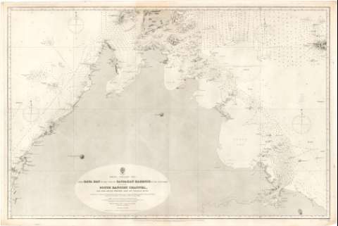
Uniform title: SANDAKAN (Malasia). Cartas náuticas. 1883 (1844-1882). 1:300000
Title: Borneo Northern part from Gayabay on the West, to Sandakan Harbour on the East Coast, including South Banguey Channel, and the south Western part of Cagayan sulu / from Surveys by Captain Sir E. J.W. Reed, R.N. 1868-9 ; Commander W. Chimmo R.N. 1871-2 ; and Lientenant R.F. Hoskyn ; and the Officers of H.M.S. Flying Fish 1881 ; Engraved by Davies & Company
Material or type of resouce Area: Escala [ca. 1:300000] ; [proyec. Mercator]
Publication: London : Published at the Admiralty 1st Mar. 1883 under Superintendence Captain Sir Frederick J. Evans R.N.K.C.B.F.R.S. Hydrographer (Sold by J.D. Potter Agent for the Admiralty Charts 31 Poultry & II King St. Tower Hill??, 1883)
Physical description: 1 carta náutica ; 68'2x101'5 cm
Content type: Imagen cartográfica
Media type: computadora
Carrier type: recurso en línea
Notes: Escala hallada a partir de un grado de la latitud [= 37,2 cm]. Coordenadas referidas a un meridiano que no se especifica. Red geográfica de 1° en 1°. Orientado con estrella y media lis en gráfico de declinación magnética
Relieve representado por normales
Indica veriles, bajos y sondas batimétricas en brazas. Clave hidrográfica para determinar la calidad del fondo
Nota relativa a la variación magnética y a las lineas que indican las zonas peligrosas para los barcos
Procede de la 'Colección Coello'
Sello de la Hydrographical Office
Materia / lugar / evento: Cartas náuticas
Bahías
Islas
Topónimos antiguos
Sandakan (Puerto)
Gaya (Bahía)
Cagayán de Joló (Isla)
Other authors: Belcher, Edward
Reed, J.W
Chimmo, William
Hoskyn, R.F
Gran Bretaña. Hydrographic Department
Davies & Company
UDC: 912:[551.46:627.231](91 Sandakan)'1844-1882'
(91 Cagayan, isla)
Type of publication:
Maps
Rights:
Préstamo:
Disponible
