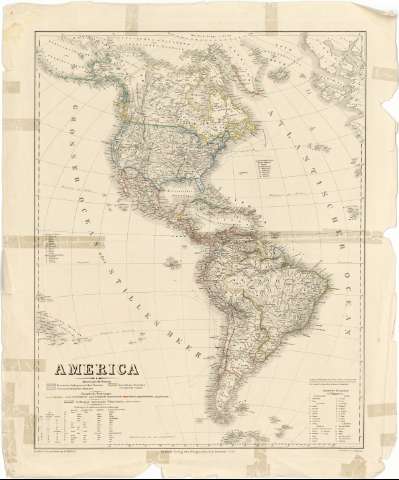
America


Section: Maps, plans and nautical charts
Uniform title: AMERICA. Mapas generales (1851). 1:26143765
Title: America / Bearbeitet und gezeichnet von H. Kiepert ; Gestochen V.C. Jungmann
Material or type of resouce Area: [Ca. 1:26143765]
Publication: Weimar : Verlag des Geographischen Instituts, 1851
Physical description: 1 mapa : col. ; 64 x 51 cm
Content type: Imagen cartográfica
Media type: computadora
Carrier type: recurso en línea
Notes: Escala gráfica de 120 millas geográficas de 15 al grado [=3,4 cm]. Proyec. de Guillermo Postel meridiana. Coordenadas referidas al meridiano de Hierro (O 160 -E 50 /N 80 -S 560). Red geográfica de 10° en 10°
Relieve por normeles
Clave toponímica en castellano, portugués, inglés y alemán, por la que se determinan los principales accidentes geográficos, y núcleos de población más significativos, así como las elevaciones montañosas más acusadas de América
Señalización de los distintos países y colonias existentes, de acuerdo con la clave cromática que ocupa el angulo inferior del documento
Materia / lugar / evento: Mapas generales
Colonias
Accidentes geográficos
Núcleos de población
1851
América
Other authors: Kiepert, Heinrich
Jungmann, C
Geographisches Institut (Weimar)
UDC: 912:325.45(7/8)"1851"
7/8
Type of publication:
 Maps
Maps
Rights:
Préstamo:
 Disponible
