[Alcantara]


Section: Maps, plans and nautical charts
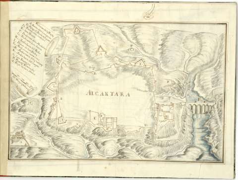
Uniform title: ALCÁNTARA (Cáceres). Fortificaciones (180). 1:8.400
Title: [Alcantara]
Material or type of resouce Area: Escala [ca. 1:8.400], 400 De varas castellanas [= 4 cm]
Publication: [180-]
Physical description: 1 plano : ms., col. ; 23 x 36 cm. en h. de 29,4 x 41 cm.
Content type: Imagen cartográfica
Media type: computadora
Carrier type: recurso en línea
Notes: Título propio redactado a partir del contenido científico del documento
Manuscrito firmado y rubricado ilegible
Relieve representado por sombreado
Manuscrito a plumilla en tinta negra y coloreado a la acuarela en varios colores
Filigrana con anagrama de escudo
Relación de los principales baluartes, puertas, fuertes y puestos de la ciudad indicada mediante clave alfabética
Figura castillo
Relación de claves y escala enmarcadas en cartela
En: Atlas de fortificaciones del Reino de Portugal y de Extremadura
Materia / lugar / evento: Fortificaciones
Castillos
S.XIX
Cáceres (Provincia)
UDC: 460.251 Alcantara
Type of publication:
 Maps
Maps
Rights:
Préstamo:
 Disponible
