Africa : with all its States, Kingdons, Republics,...


 Maps, plans and nautical charts
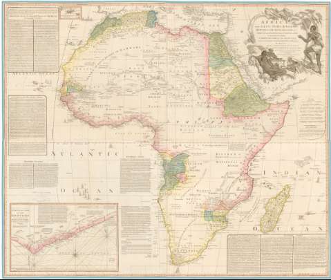
Africa : with all its States, Kingdons, Republics, Regions, Islands & Ca. : Improved and inlarged from D'Anville's... (1794)
Maps, plans and nautical charts
Africa : with all its States, Kingdons, Republics, Regions, Islands & Ca. : Improved and inlarged from D'Anville's... (1794)
 Disponible Holdings
 Section: Maps, plans and nautical charts
Title: Africa : with all its States, Kingdons, Republics, Regions, Islands & Ca. : Improved and inlarged from D'Anville's Map... Added A Particular Chart of the Gold Coast... by S. Boulton...
Material or type of resouce Area: Escala [ca. 1:], 400 English Miles [= 7,2 cm]
Publication: London : Published by Laurve & Whittle, N 53 Fleet Street, 1794
Physical description: 1 mapa : col., montado sobre tela ; 105 x 124,1 cm, pleg. en 52,3 x 62,3 cm
Content type: Imagen cartográfica
Media type: computadora
Carrier type: recurso en línea
Notes: Presenta además un mapa de la Costa de Oro y otro de las Azores
Escala : 400 English Miles [=7,2 cm]
[Proyec. sinusoidal de Sanson]
Escalas gráficas en millas nautica francesas, leguas de Arabia, etc. Coordenadas referidas al meridiano de Hierro (O 20°-E 85°/N 35°-S 35°). Red geográfica de 5 en 5 . Orientado con lis en rosa de 8 vientos
Relieve de perfil
Indica la direccion de las corrientes con flecha
Notas en el interior del mapa sobre los pueblos y tierras del continente
Leyenda explicativa sobre usos, costumbres y monumentos
Título enmarcado en cartela barroca con nativos y motivos vegetales
Decoración con barcos en el mar
Materia / lugar / evento: Mapas generales
Fronteras
Topónimos antiguos
1794
África
Other authors: Boulton, S
Anville, Jean-Baptiste Bourguignon d', 1697-1782
Robert Laurie and James Whittle
UDC: 912:341.222(6)'1794'
6
Type of publication:
Maps
Rights:
Préstamo:
Disponible
