Croquis que manifiesta el terreno qe. atravesó la Sega....


 Maps, plans and nautical charts
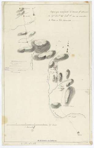
Croquis que manifiesta el terreno qe. atravesó la Sega. Divon. del Exto. 3 en su marcha de Ubeda a Villa-Hermosa (1813?)
Maps, plans and nautical charts
Croquis que manifiesta el terreno qe. atravesó la Sega. Divon. del Exto. 3 en su marcha de Ubeda a Villa-Hermosa (1813?)
 Disponible Holdings
 Section: Maps, plans and nautical charts
Uniform title: Jaén (Provincia). Operaciones bélicas (1813?). 1:143.000
Title: Croquis que manifiesta el terreno qe. atravesó la Sega. Divon. del Exto. 3 en su marcha de Ubeda a Villa-Hermosa / J. Camacho
Material or type of resouce Area: Escala [ca. 1:143.000]. 4 legs. Castells. [= 11,7 cm]
Publication: [1813?]
Physical description: 1 mapa : ms., col. ; 44 x 27,5 cm en h. de 46 x 29,2 cm
Content type: Imagen cartográfica
Media type: computadora
Carrier type: recurso en línea
Notes: Manuscrito firmado y rubricado por el autor. A plumilla en tintas negra y azul y coloreado a la acuarela en azul y verde
Orientado con flecha
Relieve representado por sombreado
Filigrana: Ansell 1807
Materia / lugar / evento: Operaciones bélicas
Reconocimiento del terreno
Guerras de independencia
1813
Jaén (Provincia)
Andalucía
España
España - Historia - 1808-1814 (Guerra de la Independencia)
Genre / form: Manuscritos
Other authors: Camacho, Juan
UDC: (460.352)
Type of publication:
Maps
Rights:
Préstamo:
Disponible
