Poloniae regnum ut et magni ducat. Lithuaniae accuratiss....


 Maps, plans and nautical charts
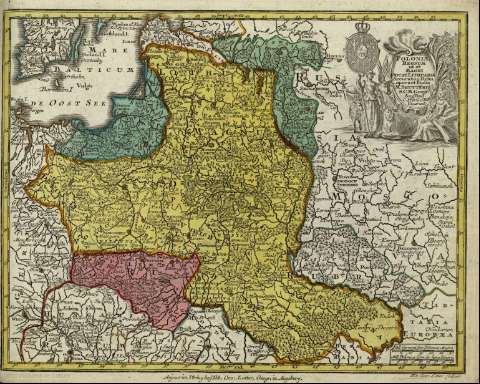
Poloniae regnum ut et magni ducat. Lithuaniae accuratiss. delin. : [tabula]
- Seutter, Matthaeus, 1678-1756
Maps, plans and nautical charts
Poloniae regnum ut et magni ducat. Lithuaniae accuratiss. delin. : [tabula]
- Seutter, Matthaeus, 1678-1756
 Disponible Holdings
 Section: Maps, plans and nautical charts
Title: Poloniae regnum ut et magni ducat. Lithuaniae accuratiss. delin. : [tabula] / opera et studio M. Seutteri S.C.M. Geogr. Aug. Vind C. Privil S.R.I. Vicariat ; Tob. Conr. Lotter sculpsit
Author: Seutter, Matthaeus, 1678-1756
Material or type of resouce Area: Escala [ca. 1:6734000], 30 mill. german. sive polonica magna [= 3'3 cm]
Publication: Augsburg : Anjezo im Verlag bey Tob. Conr. Lotter, geogr. <, [17-- ?]
Physical description: 1 mapa : col. ; 20x26 cm, en h. de 22x27 cm
Content type: Imagen cartográfica
Media type: computadora
Carrier type: recurso en línea
Notes: Escala gráfica, además en : 'mill. polonica com. siv. hora itineris'. Coordenadas : E27 -E53 /N57 -N47 . Sin especificar meridiano
Título en cartela orlada
Coloreados a mano los distintos estados
Inserta un escudo
Copia digital. España : Ministerio de Cultura y Deporte. Subdirección General de Coordinación Bibliotecaria, 2010
Materia / lugar / evento: Mapas generales - S.XVIII
Polonia
Other authors: Lotter, Tobias Conrad, 1717-1777
Related titles: Polonia. Mapas generales (1740-1777). 1:6734000
UDC: 912:[929.6:341.222](438+47)'1740/1777'
47
438
Type of publication:
Maps
Rights:
