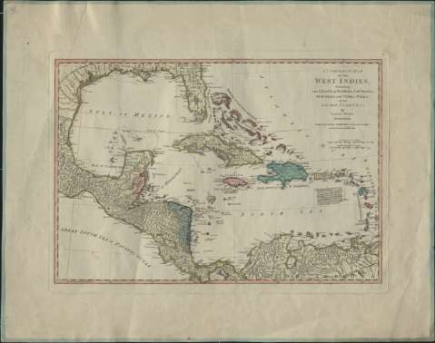
A Compleat map of the West Indies : containing the coasts...


 Maps, plans and nautical charts
A Compleat map of the West Indies : containing the coasts of Florida, Louisiana, New Spain, and Terra Firma, with... (1794)
Maps, plans and nautical charts
A Compleat map of the West Indies : containing the coasts of Florida, Louisiana, New Spain, and Terra Firma, with... (1794)
 Disponible Holdings
 Section: Maps, plans and nautical charts
Uniform title: Caribe (Mar). Cartas náuticas (1794). 1:9260000
Title: A Compleat map of the West Indies : containing the coasts of Florida, Louisiana, New Spain, and Terra Firma, with all the Islands / By Samuel Dunn
Material or type of resouce Area: Scale [ca. 1:9.260.000]. 100 sea leagues in a Degree [6,3 cm]
Publication: London : Laurie & Whittle, 53 Fleet Street, 1794
Physical description: 1 carta náutica : col. ; 31 x 45 cm
Content type: Imagen cartográfica
Media type: computadora
Carrier type: recurso en línea
Notes: Escala también expresada en 300 millas inglesas de 69 y medio al grado [= 5,4 cm]
Márgenes graduados, longitud respecto del meridiano de Ferro
Relieve representado por sombreado y montes de perfil
Indica veriles y bajos
Materia / lugar / evento: Cartas náuticas
Caribe (Mar)
Other authors: Dunn, Samuel, m. 1794
Robert Laurie and James Whittle
UDC: 261.4 Caribe
Type of publication:
Maps
Rights:
Préstamo:
Disponible
