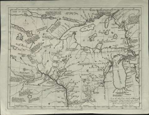
[Map of the Lake Superiour, Lake Michigan and the...


 Maps, plans and nautical charts
[Map of the Lake Superiour, Lake Michigan and the Mississippi River]
Maps, plans and nautical charts
[Map of the Lake Superiour, Lake Michigan and the Mississippi River]
 Disponible Holdings
 Section: Maps, plans and nautical charts
Uniform title: América del Norte. Mapas políticos (1783). 1:5400000
Title: [Map of the Lake Superiour, Lake Michigan and the Mississippi River] / Jonathan Carver
Material or type of resouce Area: [Ca. 1:5.400.000], 100 British statute miles [= 3,4 cm]
Publication: London : Publish'd by W.m Faden Charing Gross, Feby. 13th.1783
Physical description: 1 mapa ; 27 x 35 cm
Content type: Imagen cartográfica
Media type: computadora
Carrier type: recurso en línea
Notes: Título propio redactado a partir del contenido del documento
Dedicatoria: "To the Rt. Honble. the Earl of Hillsborough & the rest of the Lords, Commissioners for Trade & Plantations..."
Coordenadas referidas al meridiano de Londrés (O 107°25'-O 87°55'/N 51°00'-N 39°30'). Red geográfica de 2° en 2°. Orientado con flecha en cuadrante y círculo
Señala la división política
Nota explicativa sobre las principales vías de comunicación que figuran en el documento
Materia / lugar / evento: Mapas políticos
Divisiones administrativas
Estados Unidos
Canadá
América del Norte
Other authors: Carver, Jonathan, 1710-1780
Faden, William, 1749-1836
UDC: 7
Type of publication:
Maps
Rights:
Préstamo:
Disponible
