A Correct chart of the Terraquous globe : on which are...


 Maps, plans and nautical charts
A Correct chart of the Terraquous globe : on which are Described Lines shewing the variation of the magnetic Needle... (1794)
Maps, plans and nautical charts
A Correct chart of the Terraquous globe : on which are Described Lines shewing the variation of the magnetic Needle... (1794)
 Disponible Holdings
 Section: Maps, plans and nautical charts
Uniform title: AMERICA. Mapas generales. 1794 (1756?). 1:27777500
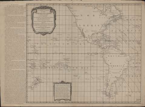
Title: A Correct chart of the Terraquous globe : on which are Described Lines shewing the variation of the magnetic Needle in the most frequented seas, originally Composed in the year 1700 / by the celebrated Dr. Edmund Halley ; renewed by Wiliam Mountaine and James Dodson F.R.S. according to Observations made about the years 1756, and new Published with all the necessary Emendations
Material or type of resouce Area: [Ca. 1:277.775.000]
Publication: London : Laurie & Wittle, as the Act directs, 1794
Physical description: 1 mapa en 2 h. ; h. de 52 x 61 cm
Content type: Imagen cartográfica
Media type: computadora
Carrier type: recurso en línea
Notes: Graduado, 10° de latitud [= 4 cm]
Cartela decorada con motivos arquitectónicos
Recuadro con orla decorada donde hay una inscripción en latín sobre la aguja magnética
Fuera del recuadro del mapa un detallado relato de la variación magnética observada
Materia / lugar / evento: Mapas generales
Magnetismo terrestre
América
UDC: 912:550.38(7/8)"1794"
7/8
Type of publication:
Maps
Rights:
Préstamo:
Disponible
