Bowles's new four-sheet map of Asia : with it's Islands...


 Maps, plans and nautical charts
Bowles's new four-sheet map of Asia : with it's Islands and Dependencies ; Comprehending also the Russian and... (Published as the Act directs 4 th. June 1789)
Maps, plans and nautical charts
Bowles's new four-sheet map of Asia : with it's Islands and Dependencies ; Comprehending also the Russian and... (Published as the Act directs 4 th. June 1789)
 Disponible Holdings
 Section: Maps, plans and nautical charts
Uniform title: Bowles's new four-sheet map of Asia. 1789. Inglés. 1:11.680.000
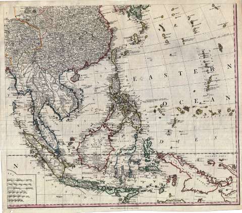
Title: Bowles's new four-sheet map of Asia : with it's Islands and Dependencies ; Comprehending also the Russian and Turkish Dominions in Europe, from the best Authorities ; the British Territory and Settlements in The East Indies, Corrected from Actual Surreys, lately made by the Company's Engineers, and a variety of new discoveries in the Maritime Parts, By Cook, Bongainville and others : The whole divided into it's Empires, Kingdom, States, & according to the most Celebrated modern Geographers
Material or type of resouce Area: [Ca. 1:11.680.000]
Publication: London : Printed for the Proprietor Carington Bowles, N° 69 St. Paul's Church Yard, Published as the Act directs, 4 th. June 1789
Physical description: 1 mapa en 4 h. : col. ; 102 x 130 cm en h. de 55 x 63
Content type: Imagen cartográfica
Media type: computadora
Carrier type: recurso en línea
Notes: En el ángulo superior izquierdo cartela ovalada rodeada de tipos humanos alegóricos de Europa y Asia, y coronada por un león, incluyendo además dos escenas típicas de este último continente
Escala gráfica de 700 millas geográficas de 60 al grado [= 11,1 cm], 190 millas alemanas, 900 estatutarias, 190 leguas marinas inglesas y francesas, 190 españolas y 190 leguas comunes de Francia. Coordenadas referidas al meridiano de Londres (E 0°-E 180°/N 80°-S 10°). Red geográfica de 5° en 5°. Orientado con lis en rosa de ocho vientos
Fronteras y límites entre las divisiones administrativas de algunos países diferenciados por colores
Indica veriles y bajos
Relieve de perfil
Reproducción digital
Genre / form: Documentos archivísticos
Mapas generales
Other authors: Bowles, Carrington, 1724-1793
España. Dirección de Hidrografía, productor. Expediciones a Indias
Museo Naval (Madrid). Archivo. Documentos gráficos, Mapas
Type of publication:
Maps
Rights:
Préstamo:
Disponible
