The asiatic part of the Russian Empire : from the Maps...


 Maps, plans and nautical charts
The asiatic part of the Russian Empire : from the Maps Published by the Imperial Academy of St. Petersburg : with... (1794.05.12)
Maps, plans and nautical charts
The asiatic part of the Russian Empire : from the Maps Published by the Imperial Academy of St. Petersburg : with... (1794.05.12)
 Disponible Holdings
 Section: Maps, plans and nautical charts
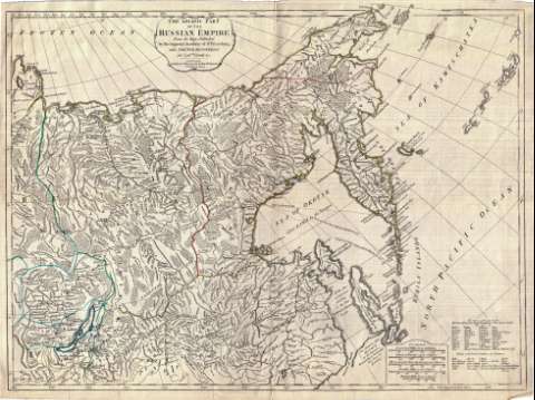
Title: The asiatic part of the Russian Empire : from the Maps Published by the Imperial Academy of St. Petersburg : with The New Discoveries of Captn. Cook & c.
Material or type of resouce Area: Escala [ca. 1:8.000.000]
Publication: London : Published by Lawrie & Whittle, N° 53 Fleet Street, 1794.05.12
Physical description: 1 mapa : col. ; 48 x 64 cm
Content type: Imagen cartográfica
Media type: computadora
Carrier type: recurso en línea
Notes: Comprende la parte oriental de la RSFS de Rusia, desde el río Anabara hasta el océano Pacífico
Escala gráfica de 300 millas geométricas de 60 al grado [= 6,9 cm], 620 verstas de Rusia de 104 al grado, 150 verstas fijadas por Pedro el Grande de 90 al grado, 60 millas británicas de 60,5 al grado. Coordenadas referidas al meridiano de Ferro (E 115°-E 210°/N 80°-N 35°). Red geográfica de 5° en 5°
Indicadas las grandes divisiones administrativas y las rutas seguidas por Cook en 1777 y 1778
Nota sobre el sur del mar de Okotsk, señalando que esa parte es copia de un mapa publicado en Petersburgo en 1787
Orografía de perfil
Tabla de conversión de términos rusos al inglés
Reproducción digital
Materia / lugar / evento: Divisiones administrativas
1794
Expediciones geográficas
Derroteros
Genre / form: Documentos archivísticos
Mapas generales
Other authors: España. Dirección de Hidrografía, productor. Expediciones a Indias
Museo Naval (Madrid). Archivo. Documentos gráficos, Mapas
Robert Laurie and James Whittle
Type of publication:
Maps
Rights:
Préstamo:
Disponible
