[Costa occidental de America del sur desde Latitud S. 3°...


 Maps, plans and nautical charts
[Costa occidental de America del sur desde Latitud S. 3° hasta Latitud S. 9°, comprendiendo parte de costas de...
Maps, plans and nautical charts
[Costa occidental de America del sur desde Latitud S. 3° hasta Latitud S. 9°, comprendiendo parte de costas de...
 Disponible Holdings
 Section: Maps, plans and nautical charts
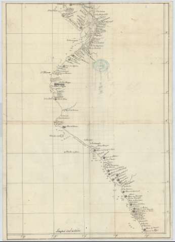
Uniform title: ECUADOR (Costa meridional). Cartas náuticas (18). 1:1792114
Title: [Costa occidental de America del sur desde Latitud S. 3° hasta Latitud S. 9°, comprendiendo parte de costas de Ecuador y Perú]
Material or type of resouce Area: Escala [ca. 1:1792114]
Publication: [18--]
Physical description: 1 carta náutica : ms., papel verjurado con marca de aguas:"F.H." con escudo, montado sobre tela ; 50 x 36 cm
Content type: Imagen cartográfica
Media type: computadora
Carrier type: recurso en línea
Notes: Comprende, en Ecuador, las costas de las provincias de El Oro, Guayas, y la parte meridional del de Manabi, y en Perú la de los departamentos de Tumbres, Piura, Lambayeque, La Libertad y la parte septentrional de la de Ancash
Título redactado a partir del contenido del documento
Escala hallada a partir de 1° de latitud [= 6'2 cm]. Red geográfica
Relieve por normales
Indica sondas batimétricas, veriles y bajos
Manuscrito a plumilla en tinta negra
Clave hidrográfica para determinar la calidad del fondo
Sello del depósito general topográfico de ingenieros
Materia / lugar / evento: Cartas náuticas
Batimetría
S.XIX
Perú
UDC: 866.14
85-16
Type of publication:
Maps
Rights:
Préstamo:
Disponible
