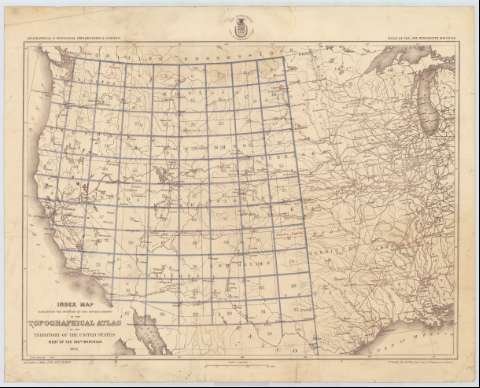
Index map exhibiting the position of the several sheets...


 Maps, plans and nautical charts
Index map exhibiting the position of the several sheets of the topographical atlas of the Territory of the United... (1873)
Maps, plans and nautical charts
Index map exhibiting the position of the several sheets of the topographical atlas of the Territory of the United... (1873)
 Disponible Holdings
 Section: Maps, plans and nautical charts
Uniform title: Estados Unidos. Mapas índice (1873). 1:6000000
Title: Index map exhibiting the position of the several sheets of the topographical atlas of the Territory of the United States West of the 100th. meridian 1873 / Louis Nell del. 1st. Lieut. Geo. M. Wheeler, Corps of Engineers in charge
Material or type of resouce Area: Escala 1:6000000 (O 126°--O 91°/N 49°--N 29°)
Publication: [Washington] : War Department. Corps of engineers U.S. Army, 1873
Physical description: 1 mapa ; 41 x 57 cm
Content type: Imagen cartográfica
Media type: computadora
Carrier type: recurso en línea
Notes: Comprende la parte occidental de los Estados Unidos, entre los estados de Washington, California, Wisconsin y Luisiana
Escala también dada en forma gráfica de 200 millas [= 5'5 cm]
En el ángulo inferior izquierdo: "Seasons of 1869, 1871, 1872 & 1873"
Figura el sello del Departamento de Guerra, Cuerpo de Ingenieros de los Estados Unidos
Materia / lugar / evento: Mapas índices
1873
UDC: 73-15
Type of publication:
Maps
Rights:
Préstamo:
Disponible
