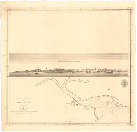
Plan of Jaffrabat on the Coast of Guzarat : Lat. 20°.51'.N.


 Maps, plans and nautical charts
Plan of Jaffrabat on the Coast of Guzarat : Lat. 20°.51'.N. (1789)
Maps, plans and nautical charts
Plan of Jaffrabat on the Coast of Guzarat : Lat. 20°.51'.N. (1789)
 Disponible Holdings
 Section: Maps, plans and nautical charts
Uniform title: India. Cartas náuticas. 1789 (1788). 1:23000
Title: Plan of Jaffrabat on the Coast of Guzarat : Lat. 20°.51'.N. / by John Mc. Cluer
Material or type of resouce Area: Escala [ca. 1:23000], 3 nautic miles [= 24,1 cm]
Publication: [London ?] : Publish'd according to Act of Parliament by A. Dalrymple Decr. 2d..., 1789
Physical description: 1 Carta náutica ; 33x34,2 cm
Content type: Imagen cartográfica
Media type: computadora
Carrier type: recurso en línea
Notes: Presenta también 1 vista
Orientado con lis en cuadrante
Relieve representado por sondas batimétricas en pies
Indica veriles, bajos y fondeaderos
Sello de la Hydrographical Office
Other authors: McCluer, John
Walker, James
Harrison, W
UDC: 912:[551.46:551.468](540-15)'1788'
540-15
Type of publication:
Maps
Rights:
Préstamo:
Disponible
