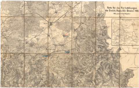
Karte fur die Herbstubungen der Grofsh, Hess (25)...


 Maps, plans and nautical charts
Karte fur die Herbstubungen der Grofsh, Hess (25) Division 1885 (149 combinirte - Brigade) (1885 ?)
Maps, plans and nautical charts
Karte fur die Herbstubungen der Grofsh, Hess (25) Division 1885 (149 combinirte - Brigade) (1885 ?)
 Disponible Holdings
 Section: Maps, plans and nautical charts
Uniform title: HESSE (Alemania). Central. Mapas generales (1885). 1:50000
Title: Karte fur die Herbstubungen der Grofsh, Hess (25) Division 1885 (149 combinirte - Brigade) / [Oficina Topográfica del E.M.]
Material or type of resouce Area: Escala 1:50000
Publication: [Alemania ? : [Editor no identificado], 1885 ?]
Physical description: 1 mapa : montado sobre tela ; 43,5x69,2 cm, pleg. en 18, 6x12,2 cm
Content type: Imagen cartográfica
Media type: computadora
Carrier type: recurso en línea
Notes: Mención de responsabilidad tomada del Catálogo del SG : 'Alemania. Siglos XVII a XIX'. 1976, p. 111
Relieve representado por normales
Inserta : Ubersichts Karte. - Escala 1:1000000
Procede de la 'Colección Coello', n. 46
Entelado en 18 cuarterones
Materia / lugar / evento: Mapas generales
Maniobras militares
1885
Reinheim
Neustadt
UDC: 912:355.52(430-328 Hesse)'1885'
(430 Reinheim)
(430 Neustadt)
Type of publication:
Maps
Rights:
Préstamo:
Disponible
