Alaska and Adjoining territory


Section: Maps, plans and nautical charts
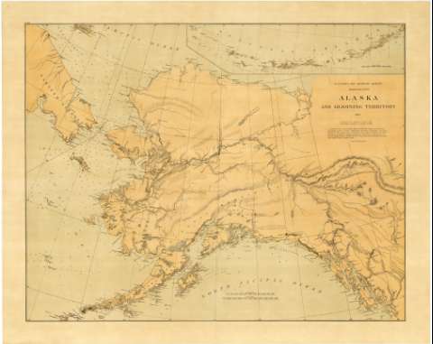
Title: Alaska and Adjoining territory / compiled fron all accesible data by W.H. Dall, Assist., U.S.C.S. and including results of recents explorations by Capt. L.A. Beardslee... and others. Dato to October 1883 ; drawn by H. Lindenkohl
Edición: Re-issued with additions in april 1884 C.O. Boutelle, Assistant in Charge of Office
Material or type of resouce Area: [Ca. 1:3000000 ; proyec. cónica] (O 188°00'-O 125°00'/N 73°30'-N 50°30')
Publication: [Washington] : U.S. Coast and Geodetic Survey, J.E. Hilgerd, Supt., 1884
Physical description: 1 mapa : col. ; 71 x 90 cm
Content type: Imagen cartográfica
Media type: computadora
Carrier type: recurso en línea
Notes: Comprende desde Fort Simpson y el estrecho de Dixon en Canadá, hasta la isla Unalaska. La continuación del mapa desde éste punto hasta la isla Attu, representando la islas Near y Aleutian, figura a modo de inserta en el ángulo superior derecho, siendo su escala [ca. 1:2700000], 100 millas náuticas [= 6'1 cm]
Escalas gráficas de 200 millas estatuarias [= 10,7 cm] y de 200 millas náuticas [= 12,4 cm]. Red geográfica de 5° en 5°
Relieve representado mediante normales u puntos acotados
Indica sondas batimétricas
Señala la frontera entre Alaska y el territorio de Yukon, destacándose la red hidrográfica y localización de los fuertes
Impreso en el ángulo superior izquierdo "No. 960"
Inserta las islas Near y Aleutian. Escala [ca. 1:2700000]
Materia / lugar / evento: Mapas generales
Batimetría
Hidrografía
Fortificaciones
1883
Yukon
Estados Unidos
Other authors: Dall, W.H
Beardslee, L.A
Boutille, C.O
Lindenkohl, H
Estados Unidos. Coast and Geodetic Survey
UDC: 912:551.48:623.1:551.46(798)"1884"
798
712.1
Type of publication:
 Maps
Maps
Rights:
Préstamo:
 Disponible
