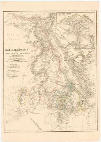
Die Nillander oder Aegypten Nubien und Mabesch


 Disponible Holdings
 Section: Maps, plans and nautical charts
Uniform title: MAR ROJO. Mapas generales (1853). 1:5000000
Title: Die Nillander oder Aegypten Nubien und Mabesch / nach C.F. Weilands Entwurf vollig umgearbeitet v. H.K iepert
Material or type of resouce Area: 1:5000000
Publication: Weimar : Verlag des Geographischen Institus, 1853
Physical description: 1 mapa : col. ; 63x49 cm en h. de 73x51,5 cm
Content type: Imagen cartográfica
Media type: computadora
Carrier type: recurso en línea
Notes: Presenta además dos mapas de detalle 'Das Nil - Delta y Alexandria'
Escala grafica de 45 geograficas millas de 15 al grado, 200 millas inglesas de 69 al grado, '75 Frauros, lieves 25 auf 1°'. Coordenadas referidas al meridiano de Hierro (E45°30'-E60°30'/N30°25'-5°0')
Relieve representado por normales
Tabla de signos convencionales para indicar, las ruinas, iglesias, etc.
Procede de la Colección Coello
Materia / lugar / evento: Mapas generales
Topónimos antiguos
1853
Egipto
Arabia Saudí
Sudán
Etiopía
Other authors: Weiland, Carl Ferdinand, 1782-1847
Geographisches Institut (Weimar)
UDC: 912:801.311(267.33)'1853'
(620)
(63)
(624)
Type of publication:
 Maps
Maps
Rights:
Préstamo:
Disponible
