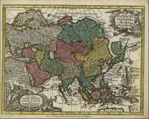
Asia cum omnibus imperiis provinciis statibus et insulis...


 Maps, plans and nautical charts
Asia cum omnibus imperiis provinciis statibus et insulis correcta et adornata : [tabula] (17--?)
Maps, plans and nautical charts
Asia cum omnibus imperiis provinciis statibus et insulis correcta et adornata : [tabula] (17--?)
 Disponible Holdings
 Section: Maps, plans and nautical charts
Uniform title: Asia. Mapas generales (1740-1777). 1:66137500
Title: Asia cum omnibus imperiis provinciis statibus et insulis correcta et adornata : [tabula] / per Matthaeum Seutter S.C.M. Geogr. Aug. Vind. Cum Pr. S.R.I. Vicariat ; A.C. Seutter delin. ; Tob. Conr. Lotter. fc
Material or type of resouce Area: [Ca. 1:66137500], 250 mill. germanica communia [= 2,8 cm]
Publication: Augsburg : Anjez im Verlaghey Tobias Conrad Lotter, Geogr., [17--?]
Physical description: 1 mapa : col. ; 25 x 20 cm en h. de 22 x 27 cm
Content type: Imagen cartográfica
Media type: computadora
Carrier type: recurso en línea
Notes: Escala gráfica además en "mill. italica et turcica, milliaria persiae, mill. magni mogol imp.". Coordenadas referidas a un meridiano que no se especifica (E 050 -E 170 /N 080 -S 006). Orientado con lis
Título en cartela orlada
Coloreados los distintos estados
Copia digital. España : Ministerio de Cultura y Deporte. Subdirección General de Coordinación Bibliotecaria, 2010
Referencias: Tooley's dictionary of mapmakers, p. 567
Materia / lugar / evento: Siglo XVIII
Asia
Other authors: Lotter, Tobias Conrad, 1717-1777
Seutter, Matthaeus, 1678-1756
Seutter, Albrecht Carl, 1722-1762
UDC: 912:341.222(5-2/-5)'1740/1777'
5
Type of publication:
Maps
Rights:
