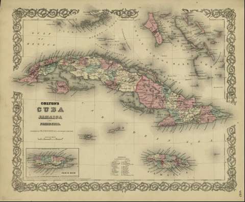
Colton's Cuba Jamaica and Puerto Rico


 Maps, plans and nautical charts
Colton's Cuba Jamaica and Puerto Rico (1872)
- Colton, G. Woolworth, 1827-1901
Maps, plans and nautical charts
Colton's Cuba Jamaica and Puerto Rico (1872)
- Colton, G. Woolworth, 1827-1901
 Disponible Holdings
 Section: Maps, plans and nautical charts
Title: Colton's Cuba Jamaica and Puerto Rico / [drawn by George Woolworth Colton]
Author: Colton, G. Woolworth, 1827-1901
Material or type of resouce Area: Escala [ca. 13.527.333], 80 miles [= 4,2 cm] (O 84º00'--O 74º20' /N 24º--N 18º)
Publication: New York : published by G.W. and C.B. Colton & Co., [1872]
Physical description: 1 mapa : col. ; 36 x 44 cm
Content type: Imagen cartográfica
Media type: computadora
Carrier type: recurso en línea
Notes: Indica meridianos de origen: Washington y Greenwich ; Márgenes graduados.
Incluye clave numérica indicando las parroquias en que se divide Jamaica.
Inserta nota: "Entered according to Act of Congress in the year 1855 by J.H. Colton & Co. in the Clerk's office of the district court for the southern district of New York".
Inserta: Porto Rico
Materia / lugar / evento: Mapas políticos
Cuba - Mapas
Jamaica - Mapas
Puerto Rico - Mapas
Bahamas - Mapas
Other authors: G.W. & C.B. Colton & Co
Related titles: Caribe (Mar). Mapas políticos (1872). 1:3527333
UDC: 912:32]:(729.1+729.2+729.5)'1872'
729.1
729.2
729.5
Type of publication:
Maps
Rights:
