Bowles's new pocket map of the discoveries made by the...


 Maps, plans and nautical charts
Bowles's new pocket map of the discoveries made by the russians on the North West coast of America (1775?)
Maps, plans and nautical charts
Bowles's new pocket map of the discoveries made by the russians on the North West coast of America (1775?)
 Disponible Holdings
 Section: Maps, plans and nautical charts
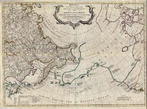
Uniform title: Bowles's new pocket map of the discoveries made by the russians on the North West coast of America (1648-1746). 1775. Inglés. 1:15200000
Title: Bowles's new pocket map of the discoveries made by the russians on the North West coast of America
Material or type of resouce Area: Escala [ca. 1:15.200.000]
Publication: [Petrogrado?] : Published by the Royal Academy of Sciences at Petersburg, [1775?] (London : Printed for the Propietor Carington Bowles N° 69 in St. Pauls Church Yard)
Physical description: 1 mapa : col. ; 45 x 62 cm
Content type: Imagen cartográfica
Media type: computadora
Carrier type: recurso en línea
Notes: Comprende la parte oriental de la RSFS de Rusia y Canadá, estando la primera completada con sus principales accidentes geográficos y la segunda sólo contorneada
Escala gráfica de 160 leguas marinas de 20 al grado [= 5,85 cm] y 600 millas estatutarias británicas de 69 1/2 al grado [= 6,2 cm]. Coordenadas referidas al meridiano de Ferro (E 90°-E 320°/N 80°-N 40°). Red geográfica de 5° en 5°
Fecha probable década 1770-1780, cuando Bowles edita este tipo de planos en la dirección indicada en el pie de imprenta
Indica las derrotas seguidas por Bering, Schestakows, Pawlutzdi y Tschirikow, señalando las fechas en que realizaron (entre 1648 y 1746)
Orografía de perfil
Tabla con traducción de términos geográficos rusos al inglés
Título enmarcado en cartela barroca
Reproducción digital
Materia / lugar / evento: Expediciones geográficas
Derroteros
Genre / form: Documentos archivísticos
Mapas generales
Other authors: Bowles, Carrington, 1724-1793
España. Dirección de Hidrografía, productor. Expediciones a Indias
Museo Naval (Madrid). Archivo. Documentos gráficos, Mapas
Imperatorskaia akademiia nauk (Rusia)
Type of publication:
Maps
Rights:
Préstamo:
Disponible
