Bowles's New Pocket Map of the Russian Empire in Europe :...


 Maps, plans and nautical charts
Bowles's New Pocket Map of the Russian Empire in Europe : comprehending also the West Part of the Empire in Asica :... (17--?)
- Anville, Jean-Baptiste Bourguignon d' 1697-1782
Maps, plans and nautical charts
Bowles's New Pocket Map of the Russian Empire in Europe : comprehending also the West Part of the Empire in Asica :... (17--?)
- Anville, Jean-Baptiste Bourguignon d' 1697-1782
 Disponible Holdings
 Section: Maps, plans and nautical charts
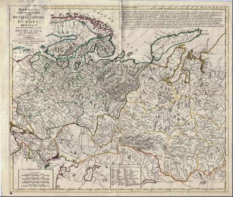
Title: Bowles's New Pocket Map of the Russian Empire in Europe : comprehending also the West Part of the Empire in Asica : from the Sr. D'Anville of the Academy of Sciences at Petersburg
Author: Anville, Jean-Baptiste Bourguignon d' 1697-1782
[Bowles's new pocket map of the East part of the Russian Empire in Asia] All editions
Characteristics of the edition: 17. 1:8000000. Inglés
Material or type of resouce Area: Escala [ca. 1:8.000.000]
Publication: London : Printed for the Propietor Carington Bowles, N° 69 in St. Pauls Church Yard, [17--?]
Physical description: 1 mapa : col. ; 48 x 56 cm
Content type: Imagen cartográfica
Media type: computadora
Carrier type: recurso en línea
Notes: Amplia explicación sobre las características geográficas e históricas de la zona representada
Comprende la parte europea de la URSS y la asiática hasta el río Yenisey
Escala gráfica de 300 millas de 60 al grado [= 6,9 cm], 620 verstas de Rusia, 450 verstas fijadas por Pedro el Grande de 90 al grado y 60 millas suecas. Coordenadas referidas al meridiano de Hierro (E 40°--E 115°/N 80°--N 50°). Red geográfica de 5° en 5°
Orografía de perfil
Principales divisiones administrativas diferenciadas por colores
Tabla de conversión de términos geográficos rusos al inglés
Reproducción digital
Materia / lugar / evento: Divisiones administrativas
Datos geográficos
Genre / form: Documentos archivísticos
Mapas generales
Other authors: Bowles, Carrington, 1724-1793
España. Dirección de Hidrografía, productor. Expediciones a Indias
Museo Naval (Madrid). Archivo. Documentos gráficos, Mapas
Type of publication:
Maps
Rights:
Préstamo:
Disponible
