Iberische Halbinsel zur zeit der Herrschaft der...


 Maps, plans and nautical charts
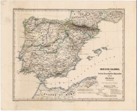
Iberische Halbinsel zur zeit der Herrschaft der Almoraviden und der Almohaden, 1086 (1094) bis 1257 (1871)
- Spruner, Karl von, 1803-1892
Maps, plans and nautical charts
Iberische Halbinsel zur zeit der Herrschaft der Almoraviden und der Almohaden, 1086 (1094) bis 1257 (1871)
- Spruner, Karl von, 1803-1892
 Disponible Holdings
 Section: Maps, plans and nautical charts
Title: Iberische Halbinsel zur zeit der Herrschaft der Almoraviden und der Almohaden, 1086 (1094) bis 1257 / $cVon K.v. Spruner ; revis. v. Th. Menke ; Gez. v. Mayr. u. Hassenstein
Author: Spruner, Karl von, 1803-1892
[Iberische Halbinsel zur zeit der Herrschaft der Almoraviden und der Almohaden, 1086 (1094) bis 1257] All editions
Characteristics of the edition: 1871. 1:3.700.000. Alemán
Material or type of resouce Area: Escala 1:3.700.000
Publication: Gotha : Justus Perthes, 1871
Physical description: 1 mapa : grab., col. ; 33 x 40 cm
Content type: Imagen cartográfica
Media type: computadora
Carrier type: recurso en línea
Notes: Escala expresada también en 30 millas alemanas de 15 al grado [= 5,9 cm. Coordenadas referidas al meridiano de Hierro (O 7°00'-O 25°00'/N 44°10'-N 33°50'). Red geográfica de 2° en 2°
Relieve representado por normales
clave cromática señalando los límites territoriales de los reinos de Castilla, León y de la unión de ambos reinos, de Navarra, Aragón, del condado de Barcelona y de la unión entre Aragón y Barcelona. Líneas de color subrayando las ciudades reconquistadas por los cristianos, en la época de los almorávides y los almohades de 1086 a 1257
En el margen superior izquierdo: "Erische Halbinsel N.º III" y en el superior derecho: "v. Spruner Menke Hist. Hand Atlas. N.º 16"
Materia / lugar / evento: Historia medieval
Divisiones administrativas
Imperio Islámico
Reinos cristianos
Reconquista
1871
España
Portugal
Genre / form: Mapas generales
Other authors: Menke, Theodor, 1819-1892
Mayr
Hassenstein, Bruno, 1839-1902
Justus Perthes (Firma)
UDC: 912:(1-2/-5)(460)(469)"1086/1257"
(460)
(469)
Type of publication:
Maps
Rights:
Préstamo:
Disponible
