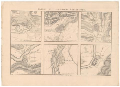
Places de L'Allemagne Méridionale


Section: Maps, plans and nautical charts
Uniform title: Alemania. S. Fortificaciones. 1838 (1701-1714). Varias escalas
Title: Places de L'Allemagne Méridionale / Dréssés au Dépôt de la guerre sous la Direction de Mr. le Lieutt. Genl. Pelet ; lith. Letronne ; Gravé par C Avril
Material or type of resouce Area: Varias escalas
Publication: [--] : [--], 1838
Physical description: 6 planos en 1 h. ; 20 x 22 cm o menos en h. de 56 x 77 cm
Content type: Imagen cartográfica
Media type: computadora
Carrier type: recurso en línea
Notes: Relieve representado por sombreado
Fecha de publicación tomada de la obra en la que se encuentra el mapa
Red hidrográfica y de caminos. Arbolado
Contains: . [Neubourg](Escala 1:15.000). [Rattenberg](Escala 1:7.500). [Ulm](Escala 1:20.000). [Scharding](Escala 1:7.500). [Villingen](Escala 1:15.000). [Kufstein](Escala 1:7.500)
Other titles: En: Atlas des mémoires militaires relatifs a la succession d'Espagne sous Louis XIV. - Paris : Imprimerie royale, 1836-[1862]. - [T. 2]
Materia / lugar / evento: Guerra de Sucesión
Fortificaciones
Fortalezas militares
1701-1713
Alemania
Genre / form: Planos militares
Other authors: Pelet, Jean-Jacques-Germain, 1777-1858
Avril, Charles
Francia. Dépôt de la guerre
Lithographie de L. Letronne
Related titles: Título: Neubourg
Título: Rattenberg
Título: Ulm
Título: Scharding
Título: Villingen
Título: Kufstein
UDC: [912:355.4]:623.2(430.1)'1701/1714'
912:314(430.1)(084.3)
430.1
Type of publication:
 Maps
Maps
Rights:
Préstamo:
 Disponible
