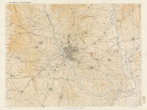
Madrid e dintorni


Section: Maps, plans and nautical charts
Uniform title: Madrid (Provincia). Mapas topográficos. 1937. 1:50.000
Title: Madrid e dintorni / Comando Truppe Volontarie, Sezione Topocartografica
Material or type of resouce Area: Escala 1:50000
Publication: [Vitoria] : C.T.V., Sez. Topocartografica, 1937
Physical description: 1 map. : col. ; 64 x 86 cm, pleg. en carpetilla 17 x 24 cm
Content type: Imagen cartográfica
Media type: computadora
Carrier type: recurso en línea
Notes: Red geográfica de 1' en 1'
Comprende el término municipal de Madrid y alrededores con límites en Getafe, Majadahonda y Torrejón de Ardoz
Coordenadas referidas al meridiano de Madrid (O 0º14'-E 0º14'/N 40º33'-N 40º17')
Relieve representado por curvas de nivel equidistantes 20 metros, puntos acotados y tinta hipsométricas
Materia / lugar / evento: Madrid (Comunidad Autónoma) - Mapas
Genre / form: Mapas topográficos
Other authors: Comando Truppe Volontarie
UDC: 912.43(460.27)"1937"
460.27
Type of publication:
 Maps
Maps
Rights:
Préstamo:
 Disponible
