West - Persien, oder die Westliches Stufenlander des...


 Maps, plans and nautical charts
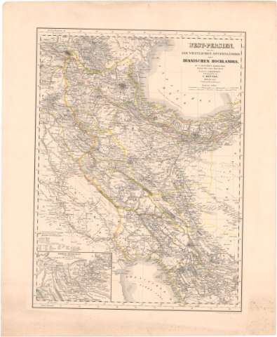
West - Persien, oder die Westliches Stufenlander des Tranischen Hochlandes (1852)
Maps, plans and nautical charts
West - Persien, oder die Westliches Stufenlander des Tranischen Hochlandes (1852)
 Disponible Holdings
 Section: Maps, plans and nautical charts
Uniform title: IRAN. Mapas generales (1852). 1:3000000
Title: West - Persien, oder die Westliches Stufenlander des Tranischen Hochlandes / zu C. Ritter's Erdkunde... ; Bearbeitet von H. Riepert
Material or type of resouce Area: Escala 1:3000000 ; [proyec. cónica] (E42°20'-E55°00'/N40°20'-N28°00')
Publication: Berlin : Verlag von Dietrich Reimer, 1852 (Geo - lithograph. Anstalt v. H. Mahlmann)
Physical description: 1 mapa : col. ; 48,7x36,4 cm en h. de 58,2x47,7 cm
Content type: Imagen cartográfica
Media type: computadora
Carrier type: recurso en línea
Notes: Escalas gráficas de 30 millas geográficas [= 7,4 cm] y 45 'Farsangs' [= 7,4 cm]. Coordenadas además referidas al meridiano de Hierro (E60°20'-E72°40'/N40°20'-N28°00'). Red geográfica de 1° en 1°
Relieve representado por normales
Publicado además por C. Ritter
Tabla de signos convencionales para indicar divisiones administrativas, caminos y nombres geográficos
Inserta : Chiraz, Persepolis und umgegend in doppeltem Maafsstab der Hauptkarte. - Escala [ca. 1:3000000] hallada a partir de un grado de la latitud [= 3,6 cm]
Materia / lugar / evento: Mapas generales
Divisiones administrativas
1852
Irak
Arabia
Other authors: Kiepert, Heinrich
Ritter, Karl
Mahlmann, Heinrich
Dietrich, Reimer
UDC: 912(55)'1852'
(567-11)
(532-18)
Type of publication:
Maps
Rights:
Préstamo:
Disponible
