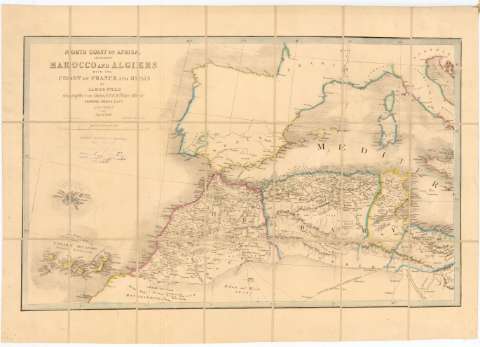
North Coast of Africa Including Marocco and Algiers with...


 Maps, plans and nautical charts
North Coast of Africa Including Marocco and Algiers with the Coast of France and Spain (1844)
Maps, plans and nautical charts
North Coast of Africa Including Marocco and Algiers with the Coast of France and Spain (1844)
 Disponible Holdings
 Section: Maps, plans and nautical charts
Uniform title: AFRICA. NO. Mapas generales (1844). 1:5000000
Title: North Coast of Africa Including Marocco and Algiers with the Coast of France and Spain / by James Wyld Geographer to The Queen & H.R. Prince Albert Charing Cross East
Edición: 2nd ed
Material or type of resouce Area: [Ca. 1:5000000], 400 British Statute Miles [= 13 cm]
Publication: London : [Editor no identificado], 1844
Physical description: 1 mapa : col., montado sobre tela ; 39 x 63 cm en h. de 48 x 69 cm
Content type: Imagen cartográfica
Media type: computadora
Carrier type: recurso en línea
Notes: Coordenadas referidas al meridiano de Londres (O 15 50'1-E 10 30'/N 45 30'-N 25 45'). Red geográfica de 5 en 5
Relieve representado por sombreado
Other authors: Wyld, James, 1812-1887
UDC: 912:(6-16)'1844'
(649)
Type of publication:
Maps
Rights:
Préstamo:
Disponible
