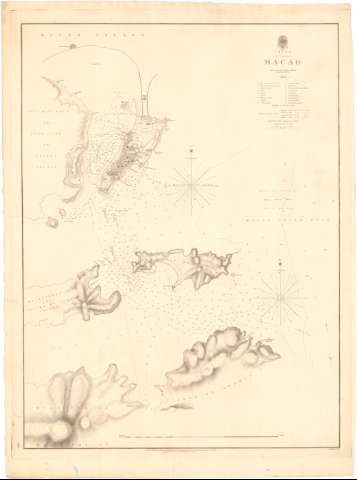
Macao : surveyed by Captn. Peter Heywood H.M.S....


 Maps, plans and nautical charts
Macao : surveyed by Captn. Peter Heywood H.M.S. Dedaigheuse 1804 (August 6th 1840)
Maps, plans and nautical charts
Macao : surveyed by Captn. Peter Heywood H.M.S. Dedaigheuse 1804 (August 6th 1840)
 Disponible Holdings
 Section: Maps, plans and nautical charts
Uniform title: MACAO. Cartas náuticas (1804). 1:25000
Title: Macao : surveyed by Captn. Peter Heywood H.M.S. Dedaigheuse 1804 / J. and C. Walker sculpr.
Material or type of resouce Area: Escala [ca. 1:25000], 2 sea miles [= 15 cm]
Publication: London : published according to Act of Parliament at the Hydrographie Office of the Admiralty, August 6th 1840
Physical description: 1 carta náutica ; 60,5x45,1 cm en h. de 67,8x49,8 cm
Content type: Imagen cartográfica
Media type: computadora
Carrier type: recurso en línea
Notes: Escala gráfica de 10 cables [= 7,5 cm]. Orientado con estrella en nudo de rumbos
Relieve representado por sombreado
Filigrana : 'J. Watmann Turkey Mill 1848'
Indica veriles, bajos, fondeaderos y sondas batimetricas
Relación de los principales edificios civiles, religiosos, etc. indicados por clave alfabética
Indica la dirección de las corrientes con flechas
Materia / lugar / evento: Cartas náuticas
Fondeaderos
Islas
Planos de población
1804
Other authors: Gran Bretaña. Hydrographic Department
J. & C. Walker
UDC: 912:[551.46:627.231:551.42](512.318)'1804'
912:314(521.318)'1804'(084.3)
Type of publication:
Maps
Rights:
Préstamo:
Disponible
