A New Map of Europe : Shewing The Different Empires,...


 Maps, plans and nautical charts
A New Map of Europe : Shewing The Different Empires, Kingdooms States & Republics with Their several Divisions from...
Maps, plans and nautical charts
A New Map of Europe : Shewing The Different Empires, Kingdooms States & Republics with Their several Divisions from...
 Disponible Holdings
 Section: Maps, plans and nautical charts
Uniform title: Europa. Mapas generales (1796). 1:1230000
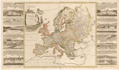
Title: A New Map of Europe : Shewing The Different Empires, Kingdooms States & Republics with Their several Divisions from the best Authorities Ornamented with Views of the Principal Cities
Material or type of resouce Area: Escala [ca. 1:1230000]
Publication: London : Publishd by Haines & son, 19 Rolls Buildings Fetter Lane (1796)
Physical description: 1 mapa : col., montado sobre tela ; 57x63 en h. de 61x54 cm
Content type: Imagen cartográfica
Media type: computadora
Carrier type: recurso en línea
Notes: Presenta además 8 vistas de algunas ciudades de Europa
Escala grafica hallada a partir de un grado de latitud [= 7 cm]. Coordenadas referidas al meridiano de Londres (O9°50'-E40°10'/N65°0'-N30°55')
Relieve de perfil
Título enmarcado en cartela barroca con motivos vegetales
Other authors: Haines & Son (Londres)
UDC: 912:341.222(4)'1796'
(6-17)
Type of publication:
Maps
Rights:
Préstamo:
Disponible
