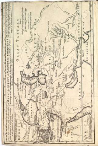
A map of the extent of Alexanders conquests According to...


 Maps, plans and nautical charts
A map of the extent of Alexanders conquests According to Mr Delifle Geographer to Lewis 14. Compared with tose of...
Maps, plans and nautical charts
A map of the extent of Alexanders conquests According to Mr Delifle Geographer to Lewis 14. Compared with tose of...
Section: Maps, plans and nautical charts
Uniform title: Irán. Mapas generales. 1700-1812
Title: A map of the extent of Alexanders conquests According to Mr Delifle Geographer to Lewis 14. Compared with tose of other Moder Geographer An: 1731 / E. Borven sculp
Material or type of resouce Area: Escala sin determinar
Content type: Imagen cartográfica
Media type: computadora
Carrier type: recurso en línea
Notes: Márgenes graduados
Indica el trópico de cancer
Meridiano de origen Bizancio
Red hidrográfica
Abundante toponimia
Costas sombreadas
En el águlo superior izquierdo nota explicativa: "This map contains only the places wich prove the exent of this Empire according to the system of the author"
En el águlo superior derecho nota explicativa: "NB The dark lines show the plan of ye. Autor, the light ones that of the modern geogrphers; and de double stroke letters show the prefent names of Countries Cities"
Copia digital. Madrid : Ministerio de Cultura, 2010
Ámbito geográfico: Mapa del imperio de Alejandro Magno en el momento de su muerte (323 a. C.), que muestra la extensión del imperio desde Macedonia en Europa hasta el río Indo, e incluye Siria y Egipto. El mapa muestra los límites del Imperio Persa y la ruta de Alejandro durante su conquista de Egipto y el Imperio Persa
Other titles: En: [The maps and plans of the Universal History]. - [Lugar de publicación no identificado] : [Editor no identificado], [1700-1812?]. - [Mapa 17]
UDC: (38)
(495)
Type of publication:
Maps
