Iberische Halbinsel von 1257 bis zur Vereinigung von...


 Maps, plans and nautical charts
Iberische Halbinsel von 1257 bis zur Vereinigung von Castilien u. Aragon 1479, und zum Fall des Königreichs Granada 1492 (1871)
- Spruner, Karl von, 1803-1892
Maps, plans and nautical charts
Iberische Halbinsel von 1257 bis zur Vereinigung von Castilien u. Aragon 1479, und zum Fall des Königreichs Granada 1492 (1871)
- Spruner, Karl von, 1803-1892
 Disponible Holdings
 Section: Maps, plans and nautical charts
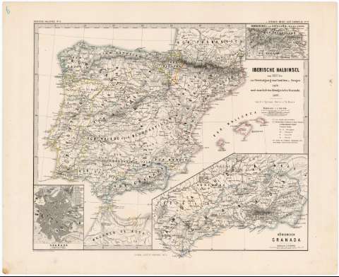
Title: Iberische Halbinsel von 1257 bis zur Vereinigung von Castilien u. Aragon 1479, und zum Fall des Königreichs Granada 1492 / Von K.v. Spruner ; revis. v. Th. Menke ; Gez. v. Mayr, Hassenstein u. Breithaupt
Author: Spruner, Karl von, 1803-1892
[Iberische Halbinsel von 1257 bis zur Vereinigung von Castilien u. Aragon 1479, und zum Fall des Königreichs Granada, 1492] All editions
Characteristics of the edition: 1871. 1:3.700.000. Alemán
Material or type of resouce Area: Escala 1:3.700.000
Publication: Gotha : Justus Perthes, 1871
Physical description: 1 mapa : grab, col. ; 33 x 40 cm
Content type: Imagen cartográfica
Media type: computadora
Carrier type: recurso en línea
Notes: Escala expresada en otras unidades. Coordenadas referidas al meridiano de Hierro (E 6°50'--E 22°00'/N 44°20'--N 34°00'). Red geográfica de 2° en 2°
Relieve representado por normales
Tabla de signos convencionales para indicar núcleos de población de distinta categoría, clave cromática para señalar los límites de los reinos de Aragón y Castilla y alfabética para diferenciar ducados, marquesados, condados y baronías
En el margen superior izquierdo: "Iberische Halbinsel N° IV" y en el margen superior derecho "v. Spruner-Menke : Hist. Handatlas N° 17"
Inserta: "Nordgrenze von Cataluña". Escala 1:1.850.000. Coordenadas referidas al meridiano de Hierro (E 19°00'--E 21°00'/N 42°30'--N 41°55'). 5,5 x 9,3 cm ; "Granada". Escala 1:27.940. 9,5 x 7,4 cm. Clave numérica con una relación de los principales edificios y calles ; "Königreich Granada". Escala 1:1.850.000. Coordenadas referidas al meridiano de Hierro (E 11°09'--E 16°00'/N 38°30'--N 36°10'). 23 x 14 cm
Materia / lugar / evento: Reconquista
Imperio Islámico
Divisiones administrativas
1871
Castilla (Corona)
Aragón (Reino)
Cataluña
Granada
Granada (Reino)
España
Portugal
Genre / form: Mapas generales
Other authors: Menke, Theodor, 1819-1892
Breithaupt, G
Mayr
Hassenstein, Bruno, 1839-1902
Justus Perthes (Firma)
UDC: 912:[314(084.3)]+(1-2/-5)(460)(469)"1257/1492"
(463/464)
(460.22-89)
(460.26)
(460.357.2)
(460.357)
(460)
(469)
Type of publication:
Maps
Rights:
Préstamo:
Disponible
