El Aaiun


 Maps, plans and nautical charts
El Aaiun (1959)
- España. Servicio Geográfico del Ejército. 1:10.000
Maps, plans and nautical charts
El Aaiun (1959)
- España. Servicio Geográfico del Ejército. 1:10.000
 Disponible Holdings
 Section: Maps, plans and nautical charts
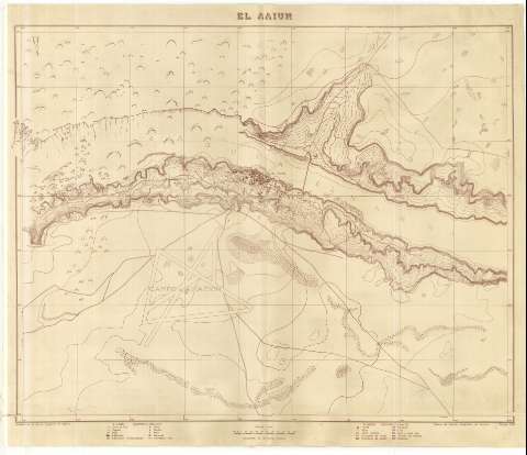
Title: El Aaiun / Levantado por el Servicio Geográfico del Ejército
Author: España. Servicio Geográfico del Ejército. 1:10.000
[El Aaiún] All editions
Characteristics of the edition: 1959. Español
Material or type of resouce Area: Escala 1:10.000
Publication: [Madrid] : Talleres del Servicio Geográfico del Ejército, 1959
Physical description: 1 plano : lit ; 82 x 104 cm
Content type: Imagen cartográfica
Media type: computadora
Carrier type: recurso en línea
Notes: Orientado con flechas indicando declinación magnética
Relieve representado por curvas de nivel con una equidistancia de 2 m
Tabla de signos convencionales para indicar: curvas de nivel, vaguadas, pistas, edificación, edificación semiconstruida, fortín, morabo, pozo, manantial, cementerio arabe, fuente, tapia, dunas, escarpado de tierra, de piedra, palmera, erial, erial y monte alto, terreno para huerta y estanque
Indica la ubicación de la ciudad, en la que destaca el campo de aviación y el sentido de sus vías de acceso
Materia / lugar / evento: Levantamiento topográfico
Infraestructura urbana
Aeródromos
1959
El Aaiún
Sáhara Occidental
Genre / form: Planos de población
Mapas topográficos
UDC: (648 El Aaiún)
Type of publication:
Maps
Rights:
Préstamo:
Disponible
