Charleston


Section: Maps, plans and nautical charts
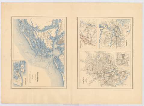
Title: Charleston / dessiné par Ed. Dumas Vorzet ; gravé par L. Wuhrer
Material or type of resouce Area: Escala 1:100.000
Publication: Paris : Michel Lévy, [18--?]
Physical description: 4 mapas en 1 h. : col. ; 64 x 45 cm
Content type: Imagen cartográfica
Media type: computadora
Carrier type: recurso en línea
Notes: Relieve representado por normales
Nota sobre el fuerte Wagner
Inserta: Fort Pulaski. Escala 1:60.000 ; Environs de Corinth ; Suffolk ; Winchester. Escala 1:125.000
Materia / lugar / evento: Perspectivas de costas
Islas
Planos de población
Núcleos de población
Ríos
S.XIX
Charleston
Corinth
Winchester (Estados Unidos, Virginia)
Carolina del Sur
Mississippi
Virginia
Estados Unidos
Other authors: Dumas-Vorzet, Edmond, 1841-1885
Wuhrer, L grabador
UDC: 757
762
755
Type of publication:
 Maps
Maps
Rights:
Préstamo:
 Disponible
