Section of map of parts of Brunswick and New Hanover...


 Maps, plans and nautical charts
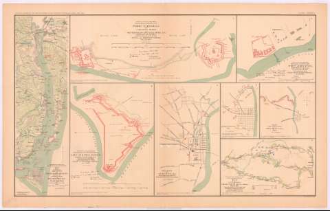
Section of map of parts of Brunswick and New Hanover Counties Showing the approaches to Wilmington, N.C. (189-?)
Maps, plans and nautical charts
Section of map of parts of Brunswick and New Hanover Counties Showing the approaches to Wilmington, N.C. (189-?)
 Disponible Holdings
 Section: Maps, plans and nautical charts
Uniform title: CAROLINA DEL NORTE (Estados Unidos). NE. Maniobras de campaña. 189 (1861-1865). 1:120700
Title: Section of map of parts of Brunswick and New Hanover Counties Showing the approaches to Wilmington, N.C. / made under the direction of Capt. W.H. James, Ch. Engr. by B.L. Blackford, 1st Lieut. Engrs.
Material or type of resouce Area: Escala [ca. 1:120700], 3 miles [= 4 cm]
Publication: Washington : Government Printing Office, [189-?] (N.Y. [Nueva York] : Julius Bien & co.)
Physical description: 1 mapa : col. ; 42x13 cm, en h. de 47x75 cm
Content type: Imagen cartográfica
Media type: computadora
Carrier type: recurso en línea
Notes: En : Atlas to accompany the Official Records of the Union and Confederate Armies 1861 - 1865. - Plate CXXXII, n 1
Relieve : líneas perpendiculares normales
Figura en margen inferior : Series I. Vol. XLVL. Page 434
Orientado con flecha
Representadas mediante color rojo las posiciones del ejército confederado
En : Atlas to accompany the Official Records of the Union and Confederate Armies 1861 - 1865
Materia / lugar / evento: Guerra civil
Maniobras de campaña
Itinerarios
Fortalezas militares
Redes de transporte
Planos de población
S.XIX
Brunswick (Condado)
New Hanover (Condado)
Wilmington
Estados Unidos
Other authors: Blackford, B.L
James, W. H
UDC: 912:355.4]:[355.52+656.02+623.1](756-18)'1861/1865'
912:314(756 Wilmington)(084.3)
756-18
Type of publication:
Maps
Rights:
Préstamo:
Disponible
