Map, from Maj. A.H. Campbell's Surveys, showing the 2d....


 Maps, plans and nautical charts
Map, from Maj. A.H. Campbell's Surveys, showing the 2d. Corps, A.N. Va., May 3d. 1864 and the routes of March from... (189-?)
Maps, plans and nautical charts
Map, from Maj. A.H. Campbell's Surveys, showing the 2d. Corps, A.N. Va., May 3d. 1864 and the routes of March from... (189-?)
 Disponible Holdings
 Section: Maps, plans and nautical charts
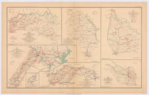
Title: Map, from Maj. A.H. Campbell's Surveys, showing the 2d. Corps, A.N. Va., May 3d. 1864 and the routes of March from May 4th. to May 21st., 1864, to battles of the Wilderness and Spotsylvancia C.H., Va. : to accompany report of Jed. Hotchkiss, Top. Eng. V.D. / Top. Engr. Office v.n. Feb. 6th. 1864, copied by S.B. Robinson
Material or type of resouce Area: Escala 1:160000
Publication: Washington : Government Printing Office, [189-?] (N.Y. [Nueva York] : Julius Bien & co.)
Physical description: 1 mapa : col. ; 19x28 cm, en h. de 47x75 cm
Content type: Imagen cartográfica
Media type: computadora
Carrier type: recurso en línea
Notes: En : Atlas to accompany the Official Records of the Union and Confederate Armies 1861-1865. - Plate LXXXI, n 1
Relieve : líneas perpendiculares normales
Leyenda de símbolos utilizados
Mapa que acompaña al informe del Cap. Jed Hotchkiss, C.S. Army Top. Engineer 2d. Corps A.N.V. (Valley District)'
Figura en margen inferior : Series I, vol. XLIII, part I
Representadas en color rojo las posiciones del Ejercito Confederado
Sobre el tit. figura : N 1
En : Atlas to accompany the Official Records of the Union and Confederate Armies 1861-1865
Materia / lugar / evento: Guerra de Secesión
Batalla de Spotsylvania
Batalla de Wilderness
Itinerarios
Redes de transporte
1861-1865
1864
Wilderness
Spotsylvania Courthouse
Estados Unidos
Other authors: Campbell, A. H. (Albert H.)
Hotchkiss, Jedediah
Robinson, S. B
Estados Unidos. Topographical Engineer Office
UDC: 912:355.4]:[355.422+656.02](755)'1864'
755
Type of publication:
Maps
Rights:
Préstamo:
Disponible
