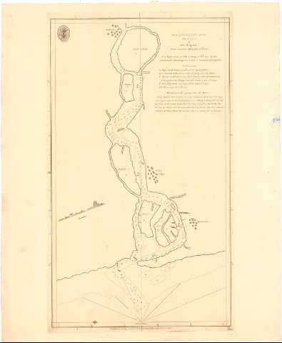
Plan of Gundiver River Lat. 20°37'N. : From Governor...


 Maps, plans and nautical charts
Plan of Gundiver River Lat. 20°37'N. : From Governor Hornoby's (1783)
Maps, plans and nautical charts
Plan of Gundiver River Lat. 20°37'N. : From Governor Hornoby's (1783)
 Disponible Holdings
 Section: Maps, plans and nautical charts
Uniform title: India. Cartas náuticas (1783). 1:26000
Title: Plan of Gundiver River Lat. 20°37'N. : From Governor Hornoby's / by John Ringrose ; WH.
Material or type of resouce Area: Escala [ca. 1:26000], 5 nautic miles [= 20 cm]
Publication: [London ?] : Publishd according to Act. of Parliament by A. Darlymple Octr. 26..., 1783
Physical description: 1 carta náutica ; 40,9x33,9 cm
Content type: Imagen cartográfica
Media type: computadora
Carrier type: recurso en línea
Notes: Orientado con lis en nudo de rumbos
Relieve representado por sondas batimétricas
Indica veriles, bajos y fondeaderos
Sello de la Hydrophical Office
Materia / lugar / evento: Cartas náuticas
Ríos
1783
Ambika (Río)
Other authors: Ringrose, John
Harrison, W
UDC: 912:[551.46:556.53](540-15)'1783'
540-15
Type of publication:
Maps
Rights:
Préstamo:
Disponible
