Grossbritannien im maassstabe von 1:1.500.000


 Maps, plans and nautical charts
Grossbritannien im maassstabe von 1:1.500.000 (1879)
- Petermann, Augustus, 1822-1878
Maps, plans and nautical charts
Grossbritannien im maassstabe von 1:1.500.000 (1879)
- Petermann, Augustus, 1822-1878
 Disponible Holdings
 Section: Maps, plans and nautical charts
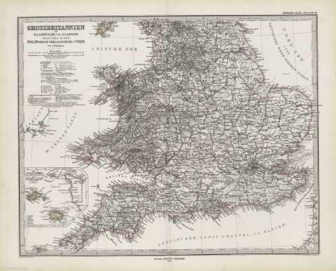
Title: Grossbritannien im maassstabe von 1:1.500.000 / Von A. Petermann ; bearb v. Ernst Debes ; Gest. v. Poppey u. Jungmann
Author: Petermann, Augustus, 1822-1878
Material or type of resouce Area: Escala 1:1.500.000 (O 7º00'-E 2º30'/N 6º55'-N 5º00')
Publication: Gotha [Alemania] : Justus Perthes, 1879
Physical description: 1 mapa en 2 h. : col. ; h. de 39 x 48 cm, pleg. en 39 x 24 cm
Content type: Imagen cartográfica
Media type: computadora
Carrier type: recurso en línea
Notes: Coordenadas referidas a los meridianos de París y Hierrro
Relieve representado por normales
Leyenda de signos utilizados
Mapa fraccionado
Inserta: "Die Canal-Inseln (Channel-Island)". Escala 1:1000000 ; "Edinburgh und Umgebung". Escala 1:150000 -- "Die Shetland und Orkney inseln im anschluss and die Hauptkarte"
En el margen superior derecho de cada hoja: "Stieler's Hand-Atlas Nº 46 y 47"
Copia digital . España : Ministerio de Cultura y Deporte. Subdirección General de Coordinación Bibliotecaria, 2010
Contenido incompleto: Contiene: Sudliches blatt : England (ohne die nördl.-Grafschaften) V. Wales ; Nördliches blatt : Schottland u. der Nördlichste theil England's
Other titles: En: Hand atlas : über alle Theile der Erde und über das Weltgebäude. - Gotha [Alemania R.D.] : Justus Perthes, [1879]. - Nº 46-47
Materia / lugar / evento: Mapas generales
Edimburgo
Gran Bretaña
Other authors: Debes, Ernst, 1840-1923
Poppey, Carl, 1829-1875
Jungmann, Carl
Stieler, Adolf, 1775-1836
Related titles: Reino Unido. 1:1500000
UDC: 912:341.222(410-2/-5)'1879'
410
912:314(410 Edimburgo)(084.3)'1879'
Type of publication:
Maps
Rights:
