Map of Nova Scotia or Acadia : With the islands of Cape...


 Maps, plans and nautical charts
Map of Nova Scotia or Acadia : With the islands of Cape Breton and St. John's from actual surveys
Maps, plans and nautical charts
Map of Nova Scotia or Acadia : With the islands of Cape Breton and St. John's from actual surveys
 Disponible Holdings
 Section: Maps, plans and nautical charts
Uniform title: NUEVA ESCOCIA (Canadá). Mapas topográficos (1768). 1:390000
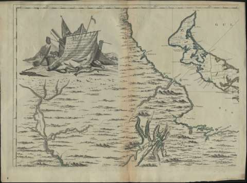
Title: Map of Nova Scotia or Acadia : With the islands of Cape Breton and St. John's from actual surveys / by Captn. Montresor
Material or type of resouce Area: Escala [ca. 1:390.000] ( (O 84°10'21''-O 75°59'46''/N 47°20'00''-N 43°30'00''), 60 miles [= 24'7 cm])
Publication: London : Printed & Sold by A. Dury in Dukes Court St Martins Lane, 1768
Physical description: 1 mapa en 4 h. : col. ; en h. de 51 x 72 cm
Content type: Imagen cartográfica
Media type: computadora
Carrier type: recurso en línea
Notes: Comprende Nueva Escocia, e islas de Cabo Bretón y Saint John que presentan sus fronteras lavadas en varios colores
Dedicatoria: To the Most Noble John Hanners Marquis of Grambi
Coordenadas referidas al meridiano de Hierro (O 49°10'-O 41°35'/N 47°20'-N 43°30'). Orientado con lis en nudo de rumbos prolongados
Relieve de perfil. Sondas batimétricas
Título enmarcado, y dedicatoria enmarcada en cartela con profusa decoración
Costas sombreadas
Materia / lugar / evento: Mapas topográficos
Cabo Bretón (Isla)
Saint Johns
Nueva Escocia
Other authors: Montrésor, John, 1736-1799
Dury, Andrew
UDC: (716)
Type of publication:
Maps
Rights:
Préstamo:
Disponible
