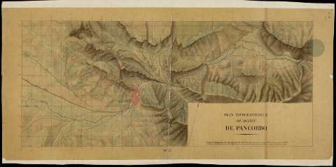
Plan topographique du Défilé de Pancorbo


 Disponible Holdings
 Section: Maps, plans and nautical charts
Uniform title: AMEYUGO (Burgos). Itinerarios (18). 1:10.000
Title: Plan topographique du Défilé de Pancorbo
Material or type of resouce Area: Escala [ca. 1:10.000]. 1.000 toesas [= 19,4 cm]
Publication: [18--]
Physical description: 1 plano : ms., col., papel vegetal ; 42 x 91,2 cm
Content type: Imagen cartográfica
Media type: computadora
Carrier type: recurso en línea
Notes: Comprende parte de los términos municipales de Pancorvo y Ameyugo en la provincia de Burgos
Orientado al norte geográfico
Relieve representado por sombreado
Aparece trazada una retícula que permite la localización de cualquier punto del área representada
Documento relacionado con: "Plan topographique de la partie de la Grande route de Bayonne á Madrid", de sig. SG. Ar.M-T.1-C.4(1), y con los de sig. SG. Ar.M-T.1-C.4-47(3),(4),(5), que completan este itinerario hasta Hernani
Materia / lugar / evento: Itinerarios
Carreteras
Guerras de independencia
S.XIX
Ameyugo
Pancorbo
Burgos (Provincia)
Castilla y León
España
España - Historia - 1808-1814 (Guerra de la Independencia)
Genre / form: Manuscritos
UDC: (460.182 Ameyuco)
Type of publication:
 Maps
Maps
Rights:
Préstamo:
Disponible
Préstamo:
Disponible
